Mar 2011
Fukushima Nuclear Power Plant Live Camera
30/03/11 12:44 Filed in: Fukushima Nuclear Plant
Fukushima Daiichi I Nuclear Power Plant Live 24 Hour Camera.
Live 24 hour video feed from the Fukushima Nuclear Power Plant.
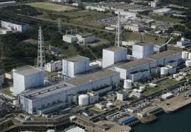
Looks as the video camera updates every five minutes.
Live 24 hour video feed from the Fukushima Nuclear Power Plant.
Looks as the video camera updates every five minutes.
Comments
RadNet Map View USA
28/03/11 20:06 Filed in: Radiation Map USA
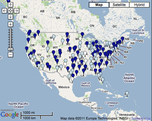
EPA's RadNet
This map is continuously being updated with scientifically reviewed data from both fixed and deployable air monitors around the U.S. The color of the pins on the map illustrate where the data is in the update process.
This map is continuously being updated with scientifically reviewed data from both fixed and deployable air monitors around the U.S. The color of the pins on the map illustrate where the data is in the update process.
The True Battle of Chernobyl Uncensored
26/03/11 12:12 Filed in: Chernobyl
Well, after watching this documentary film about Chernobyl, I have to say, I’m shocked by the true scale of this mega disaster and what could really happened if it was not handled correctly. Click here. Update 04.16.2011 Google is removing all videos from Google video servers! Grab your videos when you can.
The True Battle of Chernobyl Uncensored, local copy is here:
The True Battle of Chernobyl Uncensored, local copy is here:
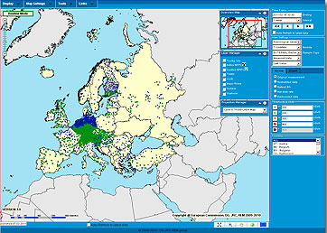
Radiation Map for Europe
22/03/11 20:00 Filed in: Radiation Map Europe
EURDEP - European Radiological Data Exchange Platform. Just got this link, interactive radiation map for Europe.
Indian Point area of potential danger
20/03/11 12:27 Filed in: Indian Point
Well, this Nuclear Power Plant is pretty safe... little leaks that surface itself when it rains (Radioactive material found near power plant :)
If disaster strikes in the nearly nuclear power plant, this is the area you really do not want to be...
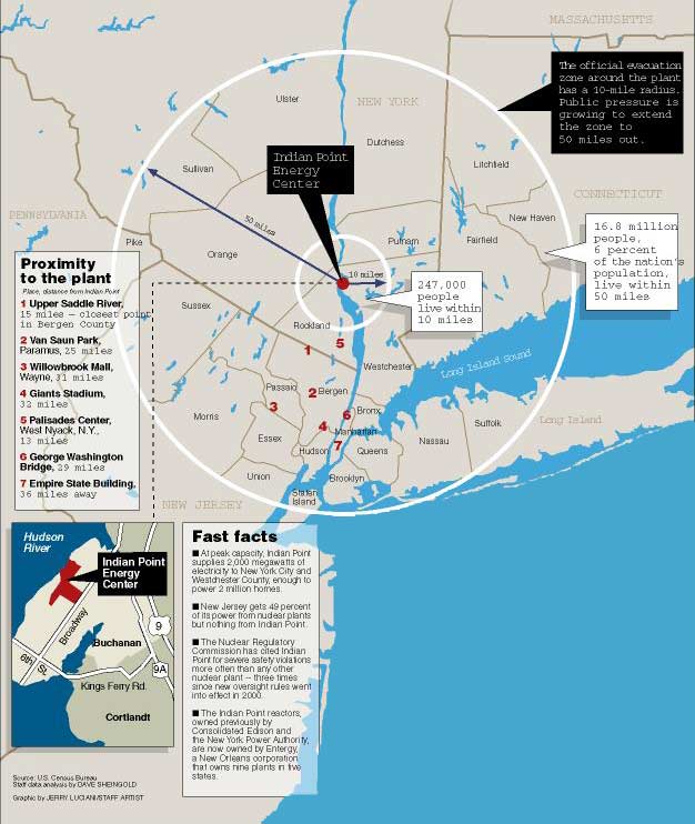
(Image and data from nci.org)
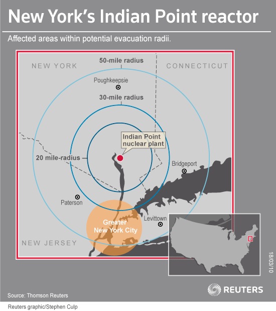
(Image and data from Reuters)
Indian Point emergency?
If there is an emergency at Indian Point, you will be notified by sirens in your area. If you hear high-pitched sirens lasting for four minutes, turn on a radio or television set and tune to the Emergency Alert System stations in your area. AM Radio FM Radio 660 92.7 770 100.7 880 103.9 1230 Television 1340 Ch. 2 WCBS 1420 Ch. 4 WNBC
The area within a 10-mile radius of the Indian Point power plant is called the Emergency Planning Zone. The federal government set the 10-mile radius as the area requiring emergency plans for protecting health and safety in radiological emergencies.
If disaster strikes in the nearly nuclear power plant, this is the area you really do not want to be...
(Image and data from nci.org)
(Image and data from Reuters)
Indian Point emergency?
If there is an emergency at Indian Point, you will be notified by sirens in your area. If you hear high-pitched sirens lasting for four minutes, turn on a radio or television set and tune to the Emergency Alert System stations in your area. AM Radio FM Radio 660 92.7 770 100.7 880 103.9 1230 Television 1340 Ch. 2 WCBS 1420 Ch. 4 WNBC
The area within a 10-mile radius of the Indian Point power plant is called the Emergency Planning Zone. The federal government set the 10-mile radius as the area requiring emergency plans for protecting health and safety in radiological emergencies.
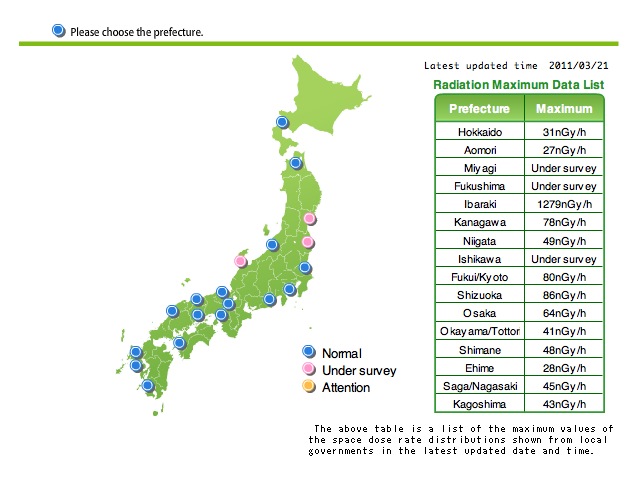
Radioactivity and radiation information - Japan
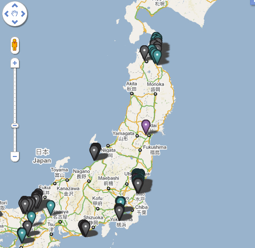
19/03/11 19:07 Filed in: Fukushima Nuclear Plant | Radiation Map Japan
- Realtime radiation data collected via the System for Prediction of Environment Emergency Dose Information (SPEEDI) Government source, may be little off...
People in Japan getting Geiger counters and setting up a private networks to monitor situation, click here
Interactive Map of Japan with radiation data, click here
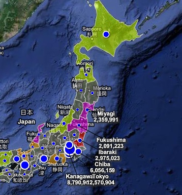
Another community driven radiation network just got turned on in Japan, click here
People in Japan getting Geiger counters and setting up a private networks to monitor situation, click here
Interactive Map of Japan with radiation data, click here
Another community driven radiation network just got turned on in Japan, click here
Indian Point evacuation plans
18/03/11 15:03 Filed in: Indian Point
Lower Hudson officials study Japan crisis, Indian Point evacuation plans.
“As they watch the unfolding nuclear crisis in Japan, emergency officials in the Lower Hudson Valley said the island nation was taking some of the same steps they might use if catastrophe struck the Indian Point reactors.” More here:
The area within a 10-mile radius of the Indian Point power plant is called the Emergency Planning Zone. The federal government set the 10-mile radius as the area requiring emergency plans for protecting health and safety in radiological emergencies.
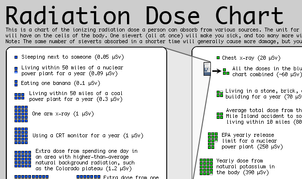
Radiation Dose Chart
17/03/11 10:37 Filed in: Radiation Information